Saturday, November 28, 2009

Visiting "The Lady Killigrew"

Rode about 34 miles from Hatfield, NH to Montague, NH (route map) with one old friend and two new ones. The was chilly, in the mid-40s, and windy. The scenery was good, but wildlife sightings nonexistent. There were some really quaint "children playing" signs (similar to this). Unfortunately, I didn't get a picture. Our turn-around was at the Book Mill in Montague, NH where we stopped for coffee and cold drinks at "The Lady Killigrew." Oddly, they don't have ice available in the colder weather. The why of that seemed logical to the server, but escaped me.

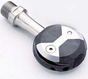
I was borrowing a friend's bike, titanium with a carbon fork and Speedplay pedals--a first for me with those three items. It was a very nice ride. Although the pedals took some getting used to, they are a very good design.

The hills were fairly mild as the route was mostly alongside the Connecticut River. Nonetheless, they were a bit of a challenge as I've been riding the flatlands of the Eastern Shore for the last couple of years. My legs were very restless while trying to sleep that night.


Saturday, November 14, 2009

Ad-libbed Ride

Water, water everywhere. The ground is saturated and there's been about 8" of rain over the last few days. There is abundant new waterfront property in the area.

It was overcast but not raining—at last. I pushed off at about 4 p.m. after watching the temperature rise throughout the day. It continued to rise during my ride. I had planned on a 25-mile loop, a reverse of my Smithville Road loop. The high tide, however, suggested a different route. The boathouse picture below is at about the far point of this loop, on Hooper Island Road (map link).

Wildlife was fairly abundant as the high water levels brought many birds close to the road, feeding in the overflowing drainage ditches. There were quite a few Great Blue Herons—always impressive up close—as well as a variety of egrets and a few ducks.

It was a good ride, about 23 miles with an average speed of 15.8 mph (route map).


Sunday, November 8, 2009

Balance and More Eagles

Did the routine 15 mile ride this evening (route map). Made it back just before it got dark enough to need a headlight. Really nothing special about the ride except that it was my first since Tuesday. It seems I was experiencing a bout of dehydration and the symptoms became quite severe on Thursday. Balancing my fluid intake is a continuing and complicated challenge.

Wildlife sightings were minimal; however, I saw a pair of bald eagles sitting in the same tree—unusual (map link). I wonder it they are the same pair I have seen elsewhere on the marsh (earlier posting). I didn't stop for a picture as I was hurried by the setting sun.

Tuesday, November 3, 2009

Passing a Telescope Riding to Taylors

This evening, I biked past a a telescope house (map link), pictured below. It's a distinctive local Chesapeake design from the 17th to early 19th centuries where two and sometimes three sections of the house are added, arrayed from smallest to largest. They were typically built over a number of years. Examples sometime are found in Pennsylvania and New England also.

I rode down to Taylors Island and had planned to include a circuit of the island; however, the road was underwater at the "Becky Phipps" monument (map link) so I turned back toward home.

It was about a 20 mile ride with an average speed of 16.8 mph.